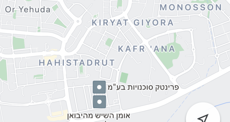
It’s unclear why Google would display the name of the village as though it is a current neighborhood in an Israeli city.
By Lauren Marcus, World Israel News
Google Maps prominently displays the names of former Palestinian localities depopulated during Israel’s 1948 War of Independence alongside the names of neighborhoods and cities in modern Israel, World Israel News has found.
When using the mobile app Google Maps to view the central Israel city of Or Yehuda, for example, one can see the names of neighborhoods within the modern-day city, such as Kiryat Giora and HaHistadrut, displayed in grey, upper case letters.
However, “Kafar ‘Ana” is also displayed in the same font and styling, with no indication that the area has been part of Or Yehuda for more than 70 years and hosts an optometrist, restaurant, and hookah lounge, among other businesses.
Kafar ‘Ana was peacefully evacuated by Israeli forces in 1948, with military records indicating that the villagers were permitted to leave the area after being searched for weapons and resettled in other Arab localities.
The town of Or Yehuda was established in 1950, almost exclusively housing Jewish refugees from the Middle East, including Iraq, Libya and Turkey, who were fleeing persecution at the hands of Muslims in their countries of origin.
It’s unclear why Google would choose to display the name of the village, which had at its peak some 3,000 residents, as though it is a current neighborhood in an Israeli city which has a population of some 37,000 people today.
Beyond Or Yehuda, Google also displays the name of the depopulated Palestinian village Sheikh Munis on the site of Tel Aviv University, and Bayit Umnuha over modern-day Beit Shemesh.
Notably, Google does not display the names of entire Jewish neighborhoods in Baghdad, Iraq – which at its peak was home to more than 130,000 Jews – that no longer exist in 2021.
Although Baghdad was once considered a major center of Jewish life and learning, all of its Jewish neighborhoods were ethnically cleansed after repeated pogroms, including the Farhud riots, and public executions of Jewish Iraqis.
Beirut’s once-bustling Jewish Quarter, known as Wadi Al Yahud (Valley of the Jews), is also absent from maps of the modern-day Lebanese city.
The tech industry titan also refrains from listing the names of former Native American localities over maps of U.S. cities.
A Ynet report from 2006 indicates that Palestinian activists mapped depopulated villages on the desktop program Google Earth, a precursor to the Maps mobile app.
It could be that the listings of Palestinian names on Israeli localities stem from an integration of data from Google Earth.
Google did not respond to a World Israel News request for comment.


