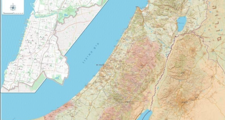
Tel Aviv mayor orders local schools to use maps displaying the Green Line, in direct violation of Education Ministry guidelines.
By Lauren Marcus, World Israel News
The Tel Aviv school district will be using maps of Israel in the upcoming school year that display the Green Line, which marks a separation between the Judea and Samaria region and the rest of the Jewish State.
Notably, the move to use maps with the Green Line is in direct violation of the Education Ministry’s curriculum guidelines.
Hebrew-language media outlets reported that the move to the new maps came after a direct order from Tel Aviv Mayor Ron Huldai.
“It is important to us that the students understand not only the city and the area where they live, but the entire country. They should know where each settlement is located, how many people live in it, and what the composition of the population is,” an official from the Tel Aviv municipality told left-wing newspaper Haaretz.
“It is important that they understand the borders between us and other countries, as well as the borders of Israeli sovereignty and the complex reality in certain areas.”
The official added that the Tel Aviv school district’s staff and administrators will know best how to “present the Israeli situation as it is in reality – sometimes controversial, sometimes subject to change and sometimes changing according to government political policy.”
Reports of the new maps immediately sparked backlash from the Education Ministry and community leaders in Judea and Samaria, who slammed the municipality for making decisions independent of nation-wide educational guidelines and reinforcing the concept that the region is not a legitimate part of Israel.
“The map was not submitted for approval by the Education Ministry and therefore it is not approved for study and not even for use as a poster on the walls,” said an Education Ministry spokesperson in a press statement.
“The only entity authorized to determine the maps of Israel is the Israel Mapping Center,” the spokesperson added, calling the Tel Aviv municipality’s decision “amateurish and unprofessional.”
“The Mayor of Tel Aviv Ron Huldai is referring to a line which is irrelevant and does not represent the consciousness of the Israeli public,” said Gush Etzion Regional Council Head Shlomo Ne’eman.
“Let’s remember that in the last Knesset election, Huldai failed on a national level and quit because he did not receive the trust of the general voting public. Now from his perch in Tel Aviv, he is trying to manipulate consciousness in regard to the inheritance of our ancestors.”
“There is a great need to apply sovereignty over Judea and Samaria, where hundreds of thousands of Jewish citizens of the State of Israel are treated as second class and any fool can decide to remove us from the map at any time,” Ne’eman added.


